
To obtain weather information, charts can be obtained through the NOAA or sites referencing this information. A briefing either through a site like DUATS or by calling a briefer at 1-800-WX-BRIEF.
Standard Briefing - contains all necessary information to plan a thorough preflight of weather.
Abbreviated Briefing - to update a previous briefing containing specific updates.
Outlook Briefing - if flight is 6 + hours away. Still need to update information prior to flight.
Observations
Observations on the surface, upper air, radar, and satellite constitute the basis for forecasts, and weather briefings.
Surface observations would include METARs through use of AWOS/ASOS systems
ARTCC (Air Route Traffic Control Center) is responsible for maintaining separation between IFR aircraft.
Upper Air Observations are gathered through weather balloons (radiosondes) that measure temperature and pressure as they rise as well as wind speed. PIREPS are another measure of real-time observations that can include turbulence, icing, and cloud tops.
Radar observations detect precipitation and wind shear.
Satellite observations contain real-time data of clouds and other weather phenomena
Service Outlets
Flight Service Stations - this is who you are calling when you dial 1-800-WX-Brief
DUATS - online method of gathering textual information on weather
En Route Flight Advisory Service (EFAS) - Frequency 122.0 MHz available when flying between 5,000 ft AGL and 17,500 ft MSL. between hours of 6am - 10pm. Provides information tailored to route of flight.
Hazardous Inflight Weather Advisory (HIWAS) - Broadcasts hazardous weather info over selected NAVAIDs such as VORs. This includes airmets, sigmets, convective sigmets, and urgent pireps.
Weather Reports
 METAR: Surface weather within 5 miles of an airport. Issued hourly unless significant weather change justifies SPECI.
EX: METAR KGGG 161753Z AUTO 14021G26 3/4SM +TSRA BR BKN008 OVC012CB 18/17 A2970 RMK PRESFR

PIREPS: Pilot Reports on observed conditions that may vary from what is in official weather observations.
EX: UA/OV GGG 090025/TM 1450/FL 060/TP C182/SK 080 OVC/WX FV 04R/TA 05/WV 270030/TB LGT/RM HVY RAIN

EX: TLX 1935 LN 8 TRW++ 86/40 199/115 20W C2425 MTS 570 AT 159/65 AUTO ^MO1 NO2 ON3 PM34 QM3 RL2=
Aviation Forecasts
Terminal Aerodrome Forecasts (TAF) - Established for the same 5sm radius as METARS, but usually only given at larger airports with significant commercial operations. Issued for 24-30 hour time period and updated 4x a day.
Ex: TAF KPIR 111130Z 111212 15012KT P6SM BKN090
TEMPO 1214 5SM BR
FM1500 16015G25KT P6SM SCT040 BKN250
FM0000 14012KT P6SM BKN080 OVC150 PROB40 0004 3SM TSRA BKN030CB
FM0400 1408KT P6SM SCT040 OVC080 TEMPO 0408 3SM TSRA OVC030CB BECMG 0810 32007KT=
Area Forecasts (FA) - Generates a picture of clouds, general weather conditions, and meteorological conditions expected over a very large area. There are 6 areas of the 48 states. Area forecasts are issued 3 x a day and valid for 18 hours.

FAUS46 KKCI 031045
FA6W
SFOC FA 031045
SYNOPSIS AND VFR CLDS/WX
SYNOPSIS VALID UNTIL 040500
CLDS/WX VALID UNTIL 032300...OTLK VALID 032300-040500
WA OR CA AND CSTL WTRS
.
SEE AIRMET SIERRA FOR IFR CONDS AND MTN OBSCN.
TS IMPLY SEV OR GTR TURB SEV ICE LLWS AND IFR CONDS.
NON MSL HGTS DENOTED BY AGL OR CIG.
.
SYNOPSIS...ALF..LRG RDG CNTRL CA-S CNTRL U.S. TROF LOW SE ALTA-SE
ID. LOW CA/MEX BDR. RDG NERN BC-HIGH N45W140. 05Z RDG N HLF CA-S
CNTRL U.S. TROF SW MAN-SE MT-SW WY. RDG NERN ALTA-HIGH WA CSTL
WTRS. LOW S CA CSTL WTRS.
SFC..CDFNT LOW SE ID-XTRM NW NV. TROF NW CA-SAN JOAQUIN VLY. 05Z
CDFNT NW CO-LOW CNTRL UT- CNTRL NV. TROF W OR-NW CA-W CNTRL CA-
SW CA.
•
SRN CA..VBG-NID-60NNW BIH LN SWD
CSTL SXNS -
 NW LAX...OVC010 TOP 015. VIS 4SM BR. BECMG 1921 SCT010 BKN CI.
OTLK...VFR.
 LAX-40N MZB...OVC010 TOP 020 CSTLN. SCT CI ELSW. 12Z OVC010. VIS
4SM BR HZ. BECMG 1618 SCT CI. OTLK...VFR.
 40N MZB-MEX BDR...OVC010 TOP 020 CSTLN. SCT CI ELSW. BECMG 1719
SCT015 CSTLN. OTLK...VFR. BECMG 0304 MVFR CIG CSTLN.
INLAND-INTR MTNS...SCT CI. OTLK...VFR.
DESERTS...SCT CI. 20Z SCT160. OCNL SCT100. 22Z ISOL -TSRA. CB TOP
FL430. OTLK...VFR.
IMPERIAL-COACHELLA VLYS...SCT CI. OTLK...VFR.
These then contain precautionary statements for IFR conditions, thunderstorm hazards and mountain obscurations.
Then a synopsis of the location and movement of pressure systems, fronts, and circulation patterns
Then VFR clouds and weather includes sky conditions and visibility for the next 12 hours and a 6 hour outlook.
Inflight Weather Advisories
Despite the name, these should be consulted prior to taking off, as they contain significant hazards to aircraft.
AIRMETs (WA) - issued every 6 hours and conditions considered hazardous especially to light aircraft. There are 3 types of Airmets = SIERRA, TANGO, and ZULU
Sierra for mountain obscurations
Tango for Turbulence
Zulu for icing
SIGMETs - (WS) considered hazardous to all aircraft. They are issued as needed, but valid for 4 hours. If related to hurricanes, it is valid for 6 hours. They are issued under alphabetic identifier from November through Yankee (not Sierra and Tango to avoid confusion)
Convective SIGMETs (WST) - Weather advisory issued for convective activity such as severe thunderstorms with high surface winds, hail greater than 3/4" diameter, or tornadoes. Issued 55 mins past the hour and valid for 2 hours.

 Winds and Temperature Aloft (FD) - Wind/Temp. forecasts for specific locations. Issued twice a day and based on radiosonde (weather balloon) observations taken at 0000Z and 1200Z. No winds are forecast when given level is within 1500 ft of station elevation. Temps not forecast within 2500 ft of station elevation.
Weather Charts
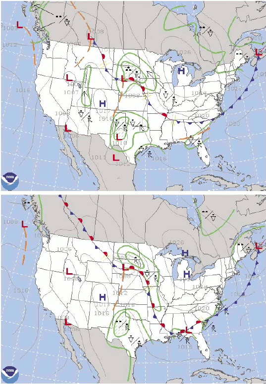
These are a graphic depiction of current or forecast weather. They typically show movement of systems and fronts.
 Surface Analysis Chart - Current surface weather. Transmitted every 3 hours. Shows pressure systems, fronts, temps, dewpoints, wind directions and speeds. All station models are present indicating sky cover and clouds.
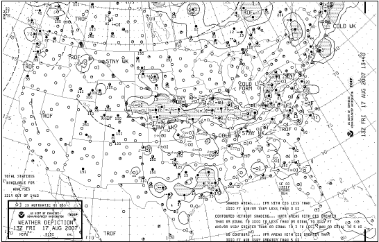


ARTCC Facilities cannot determine presence of clouds, but can see intensity of precipitation area.
Weather Avoidance
Controllers may be able to help you avoid severe weather, but remember it is not their first priority, which is to separate traffic
No comments:
Post a Comment
Note: Only a member of this blog may post a comment.